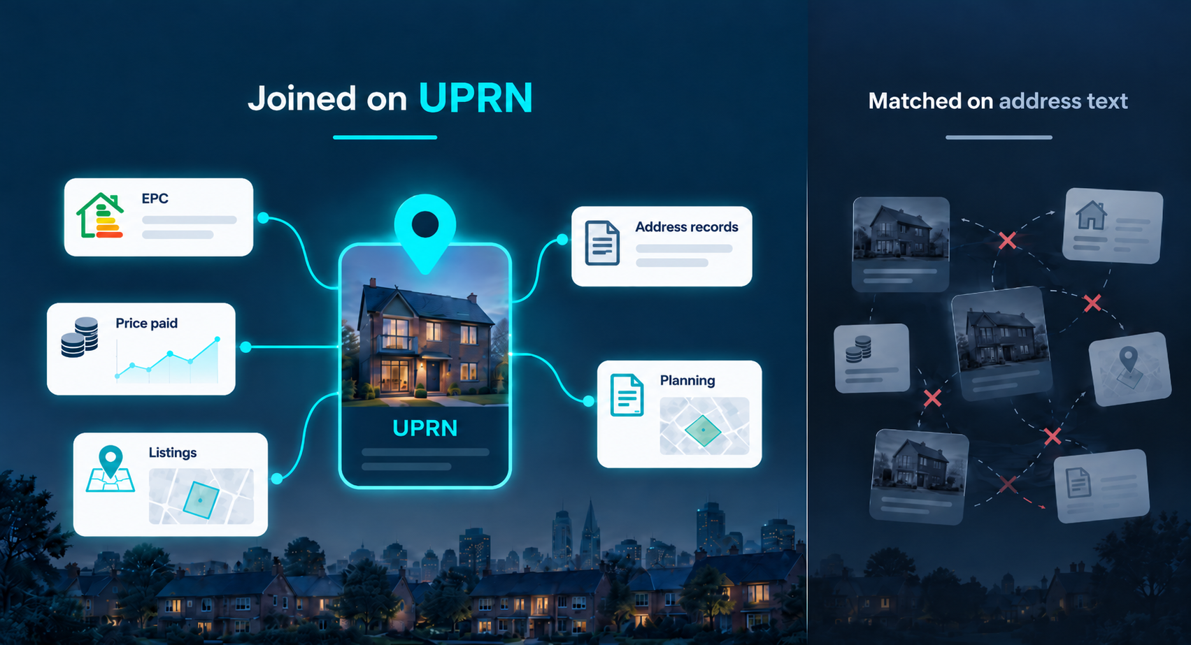
Address matching fails quietly, and it fails hardest on the properties that carry the most value: conversions, new plots, subdivided units. The UPRN is the open identifier that removes the guess, and it is published free under the Open Government Licence.
Two datasets describing the same street can return different property counts, and neither of them is wrong. One is following a building through conversion into flats. The other is waiting for Royal Mail to recognise the new delivery points. Both are matching on text that a person typed into a field.
2A and Flat 2A are the same flat, and no address matching tool will tell you so with confidence.
A UPRN is what removes the guess. It is up to 12 digits, created by Ordnance Survey, and it identifies one addressable location in Great Britain. The full set is published free under the Open Government Licence, with a coordinate attached to each record, and the Data Standards Authority has endorsed it as the open standard for identifying property.
What changes once your own records carry one is the question worth answering.
What is a UPRN, and who assigns it?
A UPRN is assigned to an addressable location and stays with it. Ordnance Survey created the identifier, local authorities create and maintain the underlying address records, and the numbers are published openly through OS Open UPRN, which pairs each identifier with a coordinate.
The important design decision is what counts as addressable. A UPRN is not limited to things that receive post. An electricity substation has one. So does a plot with planning permission and nothing built on it yet. That is why a UPRN can identify a property that has no postal address at all, and it is the first place the UPRN and the postal world part company.
What is the difference between a UPRN and a UDPRN?
A UDPRN is Royal Mail's identifier for a delivery point in the Postcode Address File. It answers a different question: where does post go. A UPRN answers which location is this.
Most of the time both exist for a house and either will do. The gap appears at the edges, and the edges are where transactions go wrong: a building being converted into flats, a plot before it is built out, a commercial unit subdivided last year. One of those may have several delivery points and one location, or a location and no delivery point yet.
| UPRN | UDPRN | A text address | |
|---|---|---|---|
| What it identifies | An addressable location, whether or not post is delivered to it | A Royal Mail delivery point | Nothing. It describes |
| Who maintains it | Local authorities and Ordnance Survey | Royal Mail, in the Postcode Address File | Whoever typed it |
| Good for | Joining datasets to the same place | Postal delivery and address capture | Reading |
| Where it fails | Coverage of any dataset attached to it still varies | Anything with no delivery point | Matching, silently |
An address describes a building. A UPRN identifies one. Most property data problems live in the gap between those two sentences.
Why do records for the same house disagree with each other?
Because each source writes the address its own way, and nothing forces them to agree. Take a first floor flat above a shop. Three systems can hold it as:
- Flat 2, 14 High Street, the way a conveyancer typed it
- 14a High St, the way a utility account shortened it
- Fourteen A, High Street, First Floor Flat, the way a planning portal expanded it
A matching routine comparing those three strings will produce one of two wrong answers. It will treat them as three properties, which inflates every count you build on it. Or it will merge two and miss the third, which quietly loses a record you needed. Neither failure announces itself.
HM Land Registry's own corporate ownership dataset states the problem plainly in its technical specification, noting that there is often inconsistency in the way addresses and names are supplied. This is not an edge case that careful data entry solves. It is what happens when independent organisations describe the same building for different purposes.
How do you use a UPRN as a join key?
You resolve once, then carry the identifier. The sequence that works in practice:
- Resolve the address you have to a UPRN, once, at the point the record enters your system.
- Store the UPRN as a field on your own record, not as a lookup you repeat.
- Join every subsequent dataset on the identifier rather than on the address text.
- Where a source gives you a UDPRN rather than a UPRN, resolve across to the UPRN and keep both.
The pay off is not tidier data. It is that a planning application, an energy certificate and a listing can be shown as facts about one building, with the confidence that they are about the same building. Without the identifier, that confidence is an assumption, and it holds right up until the week it does not.
One practical warning for anyone counting. A single property can hold several records in the same dataset, several planning applications being the obvious case. Deduplicate on the identifier before you total anything, or you will publish a number that is the same forty houses counted twice.
What can a UPRN not tell you?
It tells you which building. It does not tell you who owns it, what the tenure is, or what it is worth. It is an identifier, not a record, and treating it as a record is the most common mistake made by people who have just discovered it.
Two further limits are worth stating before anyone builds on this. Coverage of any dataset attached to a UPRN still varies by source and by area, so having the identifier does not guarantee that the data you want exists for that property. And a UPRN is a Great Britain identifier, so Northern Ireland is addressed under its own scheme.
None of that reduces its usefulness. It bounds it, which is different, and knowing the bound is what lets you rely on the parts that do work.
What to ask your own data supplier
Whether you are buying property data or building on it, three questions separate a supplier who has solved this from one who has not:
- Do you return a property identifier on every endpoint? Not on some of them. On which ones, and what comes back when they cannot resolve one.
- How do you match a record to a property? If the answer is by address string, you are inheriting their matching errors as well as your own.
- What happens when a property has more than one record? If a property can return several rows, you need to know before you build a count on it.
A UPRN identifies an addressable location in Great Britain and stays with it. A UDPRN identifies a Royal Mail delivery point. A written address identifies nothing, which is why records about the same building disagree, and why counts built on address matching are unreliable in ways that do not show up until somebody checks.
Resolve once, store the identifier, join on it, and deduplicate on it before counting. The limits are real: it does not carry ownership, tenure or value, and coverage of what is attached to it still varies by source and area.
Property data is only as good as its ability to say that two records are about the same building, and propalt.ai is built on the principle that this should be settled before anything else is claimed.
Sources and data references
- Data Standards Authority, GOV.UK. 'Identifying property and street information: UPRN.' Defines the UPRN as created by Ordnance Survey, up to 12 digits, endorsed as an open standard under Open Government Licence v3.0. alphagov.github.io/data-standards-authority/standards/UPRN
- Ordnance Survey. 'OS Open UPRN.' The open dataset pairing each UPRN with a coordinate. ordnancesurvey.co.uk/products/os-open-uprn
- GeoPlace. 'The UPRN.' Custodianship of the underlying address records by local authorities. geoplace.co.uk/addresses-streets/location-data/the-uprn
- Geospatial Commission, GDS Geospatial blog (January 2026). 'Unlocking Better Outcomes: The Power of UPRNs in Linking Data.' Government position on UPRN as a linking key. gdsgeospatial.blog.gov.uk
- Royal Mail. Postcode Address File. Source of the UDPRN as a delivery point identifier. royalmail.com/business/services/marketing/data-optimisation/paf
- HM Land Registry. 'UK companies that own property in England and Wales: technical specification.' Supports the point on address and name inconsistency across sources. use-land-property-data.service.gov.uk/datasets/ccod/tech-spec